
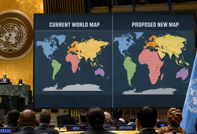
The United Nations General Assembly has backed a campaign to move the world away from the centuries-old Mercator map, arguing that the projection gives a distorted impression of the relative size of Africa and other parts of the world.
The resolution, spearheaded by Togo and supported by the African Union, was adopted on September 4 with 164 countries voting in favour, one against and six abstaining. The United States was the sole country to vote against the measure.
The resolution is not legally binding, meaning it does not force governments, schools, publishers or technology companies to abandon the Mercator projection. Instead, it encourages governments, educational institutions and digital platforms to increasingly use maps that represent the relative areas of continents more accurately.
At the centre of the dispute is a deceptively simple question: how big is Africa?
The answer is about 30.3 million square kilometres. Yet on the familiar Mercator map, Africa can appear surprisingly similar in size to Greenland. In reality, Africa is roughly 14 times larger than Greenland and is large enough to contain the United States, China, India and much of Europe within its territory.
The problem is not that the Mercator map is simply “wrong”. It was designed in 1569 by Flemish cartographer Gerardus Mercator primarily for navigation. Its great strength was preserving directions and making it useful for sailors plotting courses across the oceans.
But that usefulness comes with a price.
The Mercator projection stretches areas increasingly as they move away from the Equator. Countries and continents in the northern and southern extremes therefore appear much larger than they actually are, while regions around the Equator appear comparatively smaller. Africa, South Asia and Latin America are among those whose apparent size is reduced by the projection.
The controversy, therefore, is not really about a piece of paper.
It is about what happens when a particular picture of the world becomes so familiar that we stop questioning it.
Togo leads the challenge
Togo has emerged as the principal force behind the campaign, presenting the resolution as part of a wider effort to correct longstanding distortions in how the world is represented.
The initiative has received backing from the African Union, which had already supported calls to move governments and international organisations away from the Mercator projection.
Togo plans to update its school geography materials by the end of the year, while supporters are calling for more accurate projections to be used in textbooks, classrooms, newsrooms and digital mapping platforms.
Among the alternatives is the Equal Earth projection, introduced in 2018 and designed as an equal-area map: a projection in which the relative sizes of land masses are represented more accurately.
But Equal Earth is not the only alternative. Different projections solve different problems. Some preserve area; others prioritise shape, distance or direction. The United Nations itself says it does not prescribe one projection for all its maps and notes that different projections are used depending on the purpose and geographical scale.
That distinction matters because there is no perfectly accurate flat map of a spherical Earth. Every projection involves compromise.
US stands alone
The vote also produced an unusual diplomatic picture.
The United States was the only country to reject the resolution, while six countries abstained. Washington characterised the initiative as unnecessary and objected to what it regarded as the ideological framing surrounding the issue. Other reporting described the US position as opposition to what it called a “radical ideological project”.
The overwhelming vote in favour nevertheless gives the campaign significant political weight.
France has also moved away from the traditional Mercator representation. On September 4, France announced its adoption of the Eckert IV projection, another equal-area projection designed to represent the relative size of land masses more faithfully.
The decision raises a question that cartographers have wrestled with for generations: can a map ever be politically neutral?
A map is mathematics, but it is also a way of seeing.
The Mercator projection was created for a practical navigational purpose in 16th-century Europe. Over centuries, however, it became one of the dominant images through which generations of children learned to imagine the planet. The result is that a technical choice about navigation acquired cultural consequences.
Europe appears larger than it is. Africa appears smaller.
And repetition turns distortion into common sense.
The UN initiative does not mean that Mercator will disappear overnight. It remains useful for navigation and other specialised applications. Nor does the resolution establish a single mandatory replacement.
What it does is challenge the assumption that the map most familiar to us is necessarily the map most truthful to reality.
For Africa, that may be the most significant part of the vote.
For centuries, the continent has often been described through maps, statistics and narratives produced elsewhere. Now an African-led initiative is asking a deceptively radical question: what happens when Africa refuses to remain visually smaller than it actually is?
The answer may begin in classrooms.
But it does not end there.